|
|
Washington Publishers |

Algeria
 Algeria Flag Image Source: Wikipedia.org |
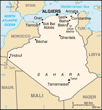 Algeria Map Image Source: CIA World Factbook |
| Algeria Webcam Coming Soon... |
|
The People's Democratic Republic of Algeria, is a presidential state in north Africa, and the second largest country on the African continent, Sudan being the largest. It is bordered by Tunisia in the northeast, Libya in the east, Niger in the southeast, Mali and Mauritania in the southwest, and Morocco as well as a few kilometers of its annexed territory, Western Sahara, in the west. Constitutionally, it is defined as an Islamic, Arab, and Amazigh (Berber) country. The name Algeria is derived from the name of the city of Algiers, from the Arabic word al-jaza’ir, which translates as the islands, referring to the four islands which lay off that city's coast until becoming part of the mainland in 1525. source: wikipedia.org |
Copyright © 2000 - 2009 All Rights Reserved Washington
Publishers
This web page is best viewed in 1024 x 768 resolution.
Last updated April 2009. Over 1,194,000 page views.
This web site is maintained by Washington Publishers, Tallahassee Florida,
USA, and uses Sun Domains and Software.
To have objectionable or potentially copyrighted material evaluated
for removal on this site, click
here.
Washington Publishers is not an affiliate of Inside
Washington Publishers.
Learn more about our current privacy
and information practices.